underbelly
Archive for
Sitting on Top of the World

Herbert Frisby and the crew of the B-29 just before the flight that took Frisby directly over the North Pole, August 12, 1956, MdHS, PAM 11,409. Frisby dropped a steel box over the exact location of the geographic North Pole, which contained a U.S. flag and a bronze memorial plaque to Matthew Henson, the first African-American to reach the North Pole.
When one thinks of arctic exploration, the state of Maryland does not immediately come to mind. But Maryland’s connection to the history of polar exploration is more than tenuous, as two of its native sons occupy prominent places on the list of travelers to the northernmost point of the earth. When Baltimorean Herbert Frisby flew over the geographic North Pole aboard a U.S. Air Force B-29 on August 12, 1956, he became the second African-American to reach the point where all longitude lines converge and every direction is south.** Frisby was following in the trail blazed by another Marylander, Matthew Henson, who forty seven years earlier, became recognized as the first African-American to set foot on the North Pole as a member of Admiral Robert Peary’s expedition, credited with reaching the pole on April 6, 1909. An arctic explorer in his own right, Frisby gained greater fame in his quest to see his fellow Marylander recognized as co-discoverer of the North Pole alongside Robert Peary.
Herbert Frisby was born on Lee Street in southwest Baltimore, near what is today Camden Yards. Details of his early life are murky—Frisby was somewhat cagey about certain details of his life, particularly his age. According to census records he was born in 1888, but in published interviews Frisby would often avoid answering direct questions about how old he was. In a 1977 Baltimore Evening Sun article he would say only that he was in his 80s. It is also unclear when Frisby first became aware of Matthew Henson. In what is most surely an apocryphal story, Frisby claimed to have first heard of the story of Henson’s voyage to the North Pole when he was in the sixth grade. In the audio excerpt below taken from an interview conducted in 1971, Frisby discusses his recollections of the event that altered the course of his life.
By all indications, Frisby was a student at Howard University at the time of the Peary expedition in 1909, having graduated from Baltimore’s Colored High and Training School (renamed Douglass high school in 1923) in 1908. He worked his way through college playing the piano and taking various odd jobs. Upon graduating in 1912, he took a teaching post at an elementary school in Baltimore, and for the next 46 years was employed in various positions in Baltimore’s public school system. By the time he retired in 1958 as head of the science department at Douglass, a position he had held for over thirty years, he was a highly regarded educator whose commentary on various subjects could often be found in the pages of Baltimore’s Afro-American newspaper.
It was perhaps in his role as a science teacher that Frisby first became fascinated with the story of Matthew Henson and decided to follow in his footsteps. During World War II he received his first opportunity when he became a war correspondent in Alaska for the Afro-American. Frisby provided readers of the newspaper with accounts of his encounters with Eskimos and his travels through Alaska and the Aleutian Islands.
Just prior to his service as a correspondent, Frisby got a chance to meet his idol. According to Frisby he spent five years traveling from his home in Baltimore in search of Henson’s birthplace, a small cabin in the tiny village of Nanemejoy on the southwestern tip of Charles County. He eventually located it, and taking a piece of wood from the cabin, he travelled to New York in search of Henson, beginning a friendship that would last until Henson’s death in 1955.
Following his hero’s death, Frisby began a one man crusade to see Henson recognized as co-discoverer of the North Pole alongside Robert Peary. There had been many supporters to Henson’s claim, including the Afro-American, that he arrived at the Pole before the exhausted Peary. But Peary, as leader of the expedition, received credit for arriving first. Henson’s lack of recognition was also due in no small part to the color of his skin, and for much of the first half of the twentieth century he was largely ignored. Frisby took it upon himself to change this.
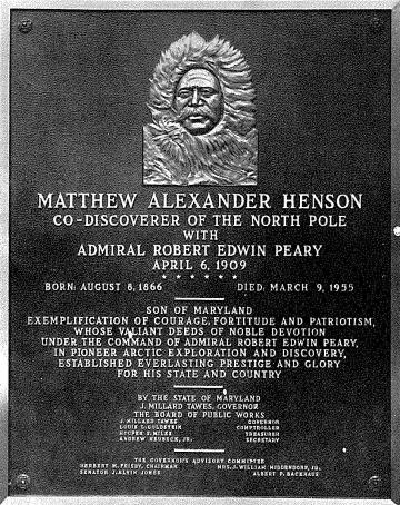
Image of the Matthew Henson Memorial Plaque located in the Maryland State House, Annapolis, MdHS, PAM 11,409.
In 1955, Frisby established the Matthew Henson Memorial Project dedicated to commemorating Henson’s life and accomplishments. Four years later, Governor J. Millard Tawes established April 6 as Matthew Henson Day in Maryland. In 1962, largely through Frisby’s advocacy, Baltimore City Public School #29, located on North Payson Street, was renamed the Matthew Henson Elementary School. Frisby’s ultimate dream was realized on August 8, 1966, when a memorial plaque commemorating Matthew Henson’s arrival at the North Pole was unveiled at the Maryland State House. Bearing the inscription, “Matthew Alexander Henson, Co-Discover of the North Pole with Admiral Robert Edwin Peary, April 6, 1909,” the plaque was the first official endorsement of Matthew Henson and Robert Peary as equal partners in their expedition to the North Pole.
Another goal not realized in Frisby’s lifetime, was the fulfillment of Henson’s request to be buried in Arlington National Cemetery near the grave of Admiral Peary. In 1988, Henson’s remains were exhumed from Woodlawn cemetery in New York City and re-interred near Peary’s grave.
Frisby achieved a good deal of renown in his lifetime for his efforts on behalf of Matthew Henson, but he also received significant attention for his own arctic travels. By the time Frisby died in 1983, he had made over 26 trips to the polar regions—on one expedition he spent two months sharing an igloo with an Eskimo family. Reports of these excursions were often printed in the pages of the Afro-American. In 1965, a group of women inspired by Frisby’s accomplishments as an educator and explorer, established the Herbert M. Frisby Historical Society. The organization worked to promote the study of African-American history as well as continuing Frisby’s mission of promoting the legacy of Matthew Henson. In 1977 Mayor William Donald Schaeffer designated March 6 as Herbert M. Frisby Day in Baltimore in honor of the explorer’s life and accomplishments.
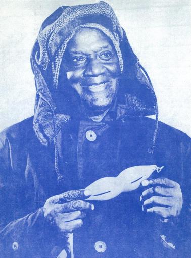
Herbert M. Frisby, undated, MdHS, PAM 11,409. Frisby is holding a pair of traditional Inuit snow goggles used to prevent snow blindness.
The story of Frisby’s quest to gain Matthew Henson recognition as “co-discoverer of the North Pole” is not without irony. Doubts over whether Henson and Robert Peary reached the pole have been widespread since their story was first announced to the world in the pages of the New York Times. Peary and another American explorer, Frederick Cook, emerged from the arctic wilderness in September of 1909 within a week of one another, with Cook claiming to have discovered the North Pole on April 21, 1908, a full year ahead of Peary. Both have had their share of detractors, but for most of the twentieth century Peary’s claim has been generally viewed as the more credible. In 1911, Peary’s claim was even formally endorsed by the U.S. Congress, although they too had strong reservations over the veracity of Peary’s claims.
In recent decades, the doubts have only increased. Another aspirant to the title of “discover of the North Pole,” American aviator Richard Byrd, who claimed to have flown over the pole by plane on May 9, 1926, has largely been discredited as well. Although the debate will probably never be conclusively resolved, today, credit is generally given to Norwegian Roald Amundsen as the being the first to arrive at the North Pole. Amundsen, who was also the first to reach the geographic South Pole in 1911, flew over the pole in a dirigible with his 15 man expedition on May 12, 1926, just a few days after Byrd claimed to.
So in all likelihood, Herbert Frisby, who is probably more remembered for his role as champion of Matthew Henson, rather than for his own arctic exploits, was the first African-American to reach the top of the world. (Damon Talbot)
**The geographic North Pole is the northernmost point of the earth, and is the direction of true north. It is the point where the earth’s axis of rotation meets its surface. The North magnetic pole is the point where the earth’s magnetic field points vertically downward and where traditional magnetic compasses point towards. The magnetic pole is in constant motion and located some 200 miles south of the geographic North Pole.
Sources and further reading:
Herbert Frisby, interview, 1971, MdHS, OH 8015.
“North Pole became this family’s guiding light,” Clarice Scriber, The Baltimore Sun, January 31, 1991.
http://www.smithsonianmag.com/history-archaeology/Cook-vs-Peary.html
http://tierneylab.blogs.nytimes.com/2009/09/07/who-was-first-at-the-north-pole/
http://www.britannica.com/EBchecked/topic/419365/North-Pole
http://www.dioi.org/vols/wa0.pdf
http://library.osu.edu/projects/byrd-north-pole/controversy.php
http://geography.about.com/od/learnabouttheearth/a/northpole_2.htm
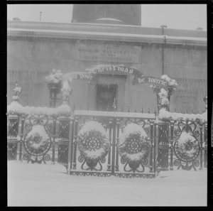
So this is Christmas…
…and here are a few images of good cheer from the Maryland Historical Society’s collection of photographs. Happy Holidays!

Santa holding little girl, ca 1930, A. Aubrey Bodine, MdHS, MC7723-5.

Santas of Volunteers of America Christmas fund, undated, A. Aubrey Bodine, MdHS, B352a.

Group portrait: Young boys and girls posing in
front of fireplace and Christmas tree, December 1949, Paul Henderson, MdHS, HEN.02.03-034.
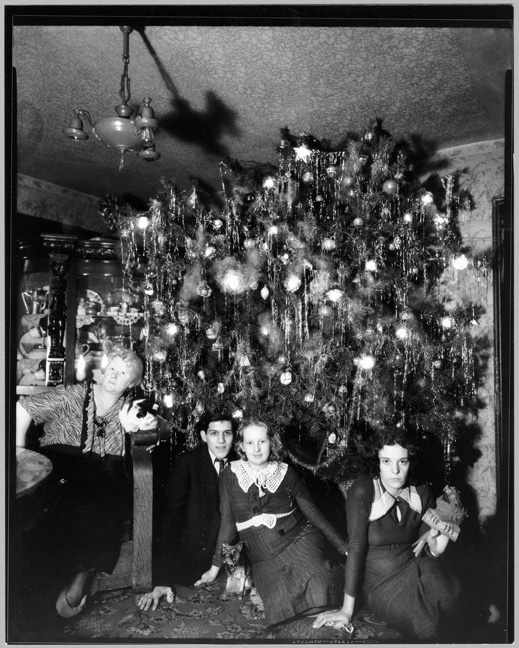
Hendrickson’s Christmas Tree, W. Franklin St., December 30, 1935, John Dubas, MdHS, MC 9269B.
Description on the rear of the photograph: Photographer John Dubas captured the joy of Christmas in 1935: a monstrous tree, its electric lights and tinsel aglow, is forced into the family parlor, and the family gathers round. At least the couple in the middle – the ones with the menacing ceramic dog – seem to be having a merry time.

Maryland Tuberculosis Association Christmas Seal Campaign.
Elephant with banner also advertising for the Hippodrome in front of City Hall, December 5, 1931, photograph by the Hughes Company, MdHS, MC6236.
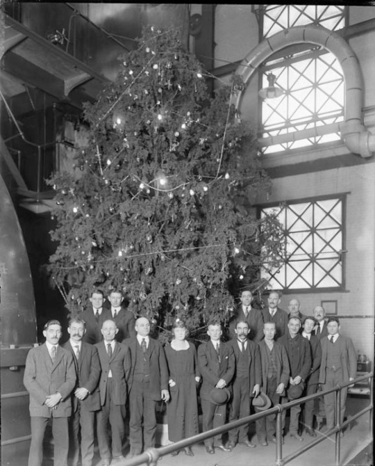
Pratt Street, Christmas Tree, United Railway Company, interior power plant, January 1912, MdHS, MC 6907.
Conduit: Mount Royal Reservoir and the Baltimore Waterworks,1857-1863
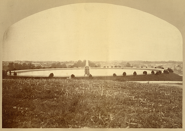
This image of the Mount Royal Reservoir was one of several photographs of the Baltimore Waterworks in 1875 that were featured in a series of A. Hoen & Co. lithographic prints. SVF-Med Photograph- Baltimore Reservoirs, MdHS
Since last month’s Hampden Reservoir post, I have taken more delight in my commute as I pass by Roosevelt Park, going to and returning from work via the Falls Road exit of the JFX; I can almost see the half moon shape of the reservoir on my left as I climb the hill approaching 36th Street. The commute home every day also served as a reminder that I needed to finish the story of the waterworks. The Hampden Reservoir was actually one of of a chain of three bodies of water, beginning with Lake Roland, and ending at the Mount Royal reservoir, where fresh water entered the city. As I began this installment of the waterworks series, I was pleasantly surprised to learn that this second forgotten reservoir in the system is also an integral part of my daily routine. My commute literally bisects its old location.

The Lake Roland dam, eight miles north of downtown on the Jones Falls. Taken from the Bromley Atlas.
After an ordinance was passed by the City Council in 1857 to provide additional water to Baltimore City, there were two options for sources: (1) to increase the amount of water taken from the Jones Falls by damming further upstream, or (2) to introduce water from the Gunpowder Falls. The engineering costs of bringing water from the Gunpowder were estimated to cost over $2.1 million, compared to around $1.3 million for construction of new works on the Jones Falls.* The Gunpowder was estimated to produce 65 million gallons of water during the dry season, while the latter was believed to provide around 20 million gallons per day. The Council chose the cheaper option.
Construction of the new waterworks from the Jones Falls began in 1858, eight miles north of the city, at a narrow point near the North Central Railroad Station. What was formerly called Swann Lake was dammed up to become what we now know as Lake Roland. A massive conduit was concurrently built connecting it to the Hampden Reservoir. Shortly thereafter a conduit was also excavated going south to the Mount Royal Reservoir just north of the city boundary. The waterworks were completed and fully operational by 1862.
The site of the Mount Royal Reservoir lay just west of the Northern Central Railroad tracks on the former site of the Mount Royal Mill property (previously the tract had been owned by Charles Carroll of Carrollton who sold it to Solomon Birckhead in 1801). The most notable feature of the reservoir was a large central fountain (see image below), similar to the one in present day Druid Lake, ornamenting the center of the reservoir with a stream of water bubbling high into the air. By 1863 just over half of the city’s 38,881 buildings received water that was delivered from the Mount Royal Reservoir.
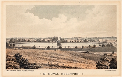
This print created by A. Hoen & Co was one of a series modeled after photographs of Baltimore Waterworks taken in 1875. Both the photographs and corresponding prints are housed in our library.
H 264.5, Hambleton Print Collection, MdHS
Even before the waterworks was fully operational it was discovered that this new source was once again insufficient for the growing population of the city. On top of the population boom during these decades, the Civil War resulted in a large number of Federal troops being stationed in, passing through, or being cared for in Baltimore hospitals. In addition to increasing the demand, sick soldiers carried typhoid, dysentery, and other diseases which were spread as a result of poor sanitation and sewage from cesspools leaching into city springs and neighborhood wells. During hot and dry periods of the summer the system would run short of supply. The Water Department’s response to the shortage was to cut down on demand by raising the price of water. The increase in cost resulted in contractors not connecting their working class tenements to the city mains, which forced tenants to rely on the same backyard pumps that had been poisoning them in the first place. As usual, the city’s low lying poor were hit hardest. Sewage from cesspools leached into neighborhood wells and polluted the springs of the city, increasing the demand for clean water from the mains.
Less than a year after the completion of the waterworks, the City Council passed an ordinance authorizing a $300,000 loan to purchase the land nearby at Lake Chapman to begin building what was to become Druid Lake. Even Druid Lake did not alleviate the supply problem when it was completed in 1865. It took severe droughts from 1869 through 1872 to finally get the city to seriously consider the Gunpowder as a permanent water source. The original price difference of $2.1 to $1.3 million payed a direct cost in human life and well-being.
In 1910 the Mount Royal Reservoir was abandoned by the City Water Department and transferred to the Parks Department. In 1924 the City Park Board demolished the reservoir and removed 50,000 cubic feet of earth, turning the site into park land. At various times proposals to turn the site into a stadium, a swimming pool, and an art museum were discussed, but due to overwhelming dissent the project never got underway. The site remained park land until 1959, when it was bisected by the northbound entrance to the new JFX highway off of North Avenue. Today you can still see the monumental entrance posts to Druid Park via Mount Royal Terrace that stand at the base of the reservoir’s original location as you drive past on North Avenue. The keen observer can glimpse the remains of the reservoir’s embankments as they pass by on the light rail. (Eben Dennis)
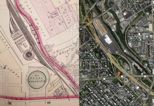
(L) Mt. Royal reservoir in 1877 from the Hopkins map of Baltimore. (R) Present day site taken from Googlemaps.
To be continued…next post – Conduit: Druid Park Lake, the Gunpowder, and Baltimore Waterworks 1860s- 1880s.
*This does not include the cost of purchasing real estate, water rights, or distribution of water mains inside the city.
** This system was upgraded to a steam pump system around the time of the annexation in 1886.
Sources
McCauley, Louis. Maryland Historical Prints. Baltimore, Md: Schneidereith and Sons, 1975.
Scharf, J. Thomas. History of Baltimore City and County. Baltimore, MD: Regional Publishing Company, 1971.
Passano File, H. Furlong Baldwin Library, Maryland Historical Society.
O’Neill, Francis. Index of Obituaries and Marriages in the Baltimore Sun, vol. 1, 1866-1870. Westminster, MD, 1996.
Mount Royal Reservoir and Its Surroundings From the Air. Baltimore Municipal Journal. Feb, 10, 1922.
Howard, William Travis. Public Health Administration and the Natural History of Disease in Baltimore, 1797-1920. Washington, DC: Carnegie Institution, 1924.
Bromley Atlas of Baltimore City and Vicinity, 1907.
Hopkins Atlas of Baltimore, 1877.
41st Annual Monument Lighting and MdHS Open House
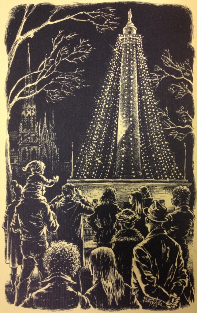
An image of the Washington Monument from Mayor William Donald Schaefer’s 1973 holiday card. Original pen and ink drawn by Baltimore artist Betty Wells. Ephemera, Series I, MdHS.
Like so much of the City of Baltimore, the annual monument lighting bears the stamp of Mayor William Donald Schaefer. Schaefer, mayor from 1971 to 1987, got the inspiration for the idea following a trip to Indianapolis in 1972, when the beauty of the city’s monuments and statues aglow in holiday lights left him in awe.* Before the annual tradition began here in Baltimore, local garden clubs had been decorating Mount Vernon Square and the Washington Monument with greenery, as can be seen below.
This photograph by A. Aubrey Bodine shows the greenery that the garden club decorated the base of the monument with in 1962, ten years before the first lighting. BCLM, B391-F, MdHS.
The Maryland Historical Society will be having an open house tonight to coincide with the 41st monument lighting here in Mount Vernon. Come join us for food, decorations, and a performance by the Notre Dame Institute’s choir. There’s even a rumor that Santa Claus himself may be showing up. The museum will be free and open to the public- see you there!
*At this point I see absolutely no evidence that they stole our football in team in retaliation for our appropriation of their decorating ideas.
The library is pleased to announce that Kory Lemmert of Mount Washington is the winner of our Movember contest. Congrats, Kory! The rest of you can check out our mustache key below.
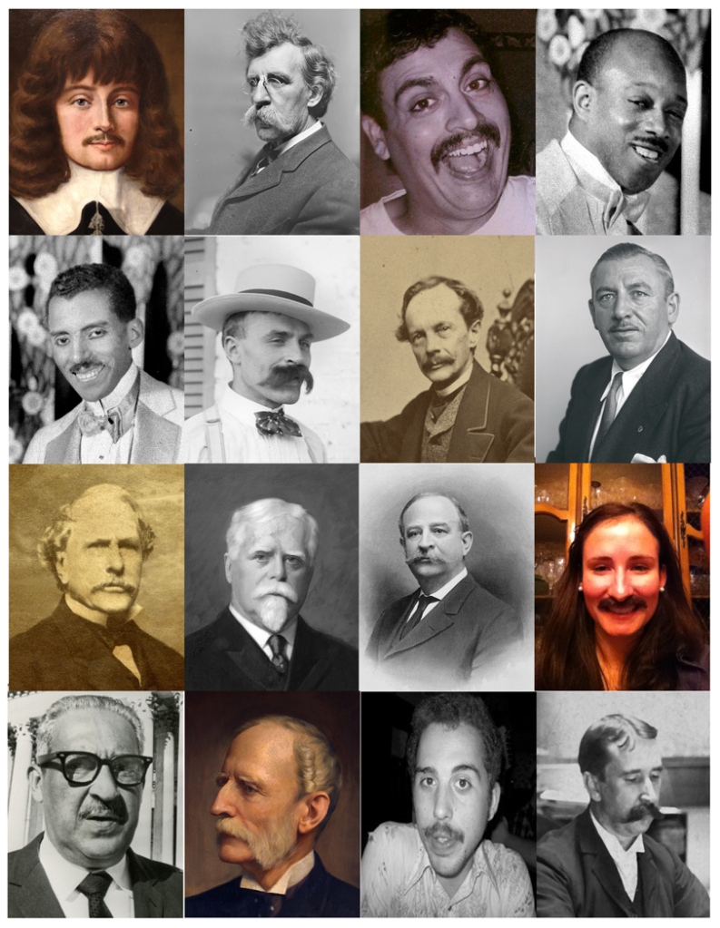
Who’s who in Maryland Historical Mustaches: 1) Leonard Calvert – Proprietary governor, 1634-1647; 2) 78-18-109 – Unknown walrus mustache (MC9484); 3) Ron Barbagallo – MdHS IT Guy; 4) Eubie Blake (Z24.1350)- jazz musician & composer; 5) Noble Sissle (Z24.1350) – jazz musician & composer; 6) Francois Dubas (MC9482) – father of photographer John Dubas; 7) George William Brown (PFV) – Mayor of Baltimore 1860-61; 8) Thomas D’Alesandro Jr. (B679-B) – Mayor of Baltimore; 9) Arunah Shepherdson Abell (MC1262) – founder Baltimore Sun; 10) Gov. Edwin Warfield – Gov. of Md 1904-08; 11) Raphael Semmes – former MdHS librarian; 12) Ms. Alex Beiter – MdHS Annual Fund Manager; 13) Thurgood Marshall – U.S. Supreme Court Justice; 14) Severn Teakle Wallis (1896-4-1); 15) David Belew – MdHS Development Coordinator; 16) Herbert Baxter Adams – first professor of history at JHU.
Sources
“Washington Monument Gets Holiday Look at Mayor’s Bidding,” Baltimore Sun, December 14, 1972.
“Deck the Streets,” Baltimore Sun, December 18, 1963.
